The Post Office must have hated this in the early days of Brookland. Changing street names.
The neighborhood’s streets have had a number of different names since the first subdivision was founded in 1887. Many of the names were never really used, but survive on subdivision maps from the early years. Before the District adopted a formalized naming system in 1901, developers named the streets, so they could vary from subdivision to subdivision. In addition, the same street could change names a number of times as it crossed subdivision boundaries. Confusion reigned.
The original 1887 plat map of the first subdivision, called simply “Brookland” contained street names based on trees – Elm St., Pine St., Walnut St., etc.

Those names were soon changed. The street names were altered at least twice before the city began officially changing them in 1901. That was when the District Commissioners adopted the basic system for the city north of Florida Avenue: north and south streets would be numbered, east and west streets would be named after distinguished Americans, alphabetically. One syllable names first, then two and finally three syllable names as you progress further north. A minor street became a “place,” and irregular streets (mostly the old ones) were termed “roads.” Broad diagonal roadways would be called “avenues,” and named after states and territories.
It took some time to get all the changes in place, and those final years between 1901 and 1905 seem the most confusing. Take, for instance, this quote from a story in the Washington Post in August, 1901:
The point of the whole matter,” a prominent District official said yesterday to a Post reporter, “is that the time is coming when Washington will be a great city: another hundred years will probably see it cover the entire District of Columbia to its remotest boundaries, and it becomes the duty of the rulers of today to take these things into consideration and to plan for the future. The Commissioners are now trying to get a system of street names for the large territory outside of the present city limits which will enable one, without trouble, to find any house of a given number. Even now the need for such a system is quite apparent.”
It didn’t take a hundred years for the city to expand to its “remotest” boundaries, but otherwise the unnamed District official was basically correct. They also expected the plan to be unpopular, and it was. District residents lodged numerous protests about the proposed changes. People who had lived on a street with one name for many years naturally resisted changing it. But eventually the new system took hold.
The evolution of the street names in Brookland shows discrepancies on different early maps, but the following chart seems to give the best indication of the original names and how they changed. The name of the street that became Lawrence is unreadable on the original plat map:
Linden St. –> Newark –> Fort –> Otis
Laurel St. –> Milwaukee –> Providence –> Newton
Elm St. –> Lowell –> Lansing –> Monroe
(unreadable) – Keokuk –> Hartford –> Lawrence
Pine St. –> Joliet –> Frankfort –> Kearny
Walnut St. –> Indianapolis –> Dover –> Jackson
Cedar St. –> Hartford –> Concord –> Irving
The numbered cross streets also changed around this time. According to a 1901 story in the Washington Post, 9th St. was originally Queen St., 10th St. was Wallace St., 12th St. was Duncan St., 13th was Burns St. and 14th was Argyle St.
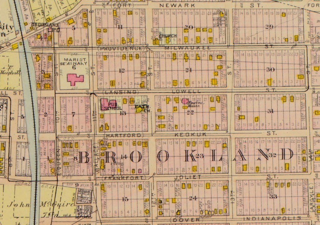
So, the big question, what happened to 11th Street? If you look at this Baist real estate map from 1903, you’ll see not only some of the old street names before they were officially changed, but you will also see an 11th Street and no 9th. Obviously, the Baist mapmakers were as confused as anyone else, based on an 1898 story from the Evening Star where the surveyor’s office says “Queen Street in old Brookland subdivision corresponds with 9th street in West Brookland subdivision; likewise Wallace street corresponds with 10th street and Duncan street corresponds with 12th.” But the Baist map, made four years later, has Queen street corresponding with 10th, and Wallace as 11th. As I said, confusion reigned. It seems to me that when they tried to line up the north/south streets with other subdivisions, either 11th or 9th street was going to have to go. Bye bye 11th Street.
As I said at the top, I’m glad I didn’t work for the Post Office back then.
