I’ve always had a fascination with the old roads in Washington DC, and how they evolved over the decades. When I started this blog in 2014, one of the first things I wrote about was the trio of old roads that comprise the boundaries of early Brookland: Bunker Hill Road, Brentwood Road, and Queen’s Chapel Road (18th Street). There’s another old road nearby that’s also worth writing about: Lincoln Road.
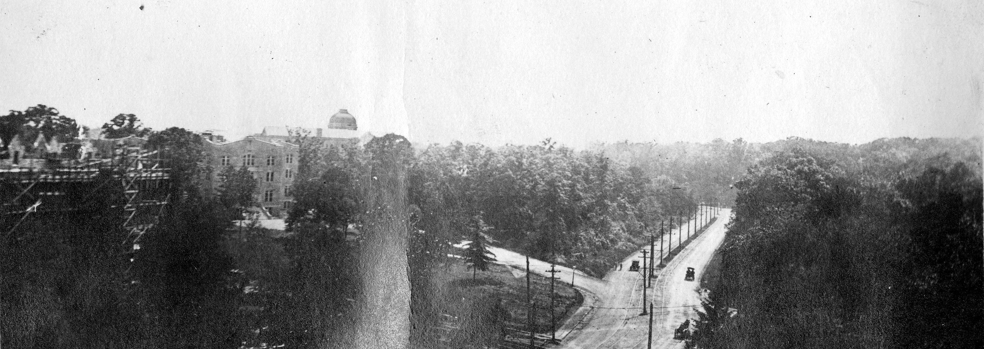
The above snapshot was taken by James Carroll, a Catholic University student, back in 1917. He was standing on the roof of Gibbons Hall, looking west down Michigan Avenue. Michigan, with a center line of utility poles, bears left around the trees and leads to Trinity College (now Trinity Washington University), the dome of their Main Hall visible against the sky. In front of that is a house of studies that belongs to the Missionary Oblates of Mary Immaculate, built just the year before. On the left edge of the photo the building with the scaffolding around it is the Sulpician Seminary, then under construction, and today called Theological College. And at the bottom center 4th Street can be seen where it meets Michigan Avenue.
Carroll pasted this photo, along with many others, into a scrapbook that has been digitized by the Catholic University Archives and made available online. The scrapbook has warped over the past century, accounting for the glare on the scan. I have looked at this photo many times, charmed by the horse-drawn cart, the early automobiles, the streetcar tracks, and even a couple of pedestrians. I assumed the roadway branching off to the left was the driveway for the Oblates, but I finally realized it is Lincoln Road at its original terminus on Michigan Avenue (Bunker Hill Road). Harewood Road lies directly across the avenue, though it is obscured by trees.
Only a mile and a half long, Lincoln Road was still a crucial thoroughfare due to its connections. It had many names over the years, beginning with Moore’s Lane, named for George and David Moore, who owned a good deal of land where the Bloomingdale neighborhood is today. It was also sometimes called the Old Bladensburg Road, because it connected to Bunker Hill Road and the colonial-era Georgetown/Bladensburg Road. It also connected to Harewood Road, which ran into Rock Creek Church Road and on out to points north. All the land north of Boundary Street (Florida Avenue) was known as Washington County, and Moore’s Lane was an important county road.

The road began at the intersection of North Capitol Street, Q Street, and Boundary Street. It passed through nothing but farms until 1852 , when William Humphreys bought the nearly 100-acre tract formerly known as Powell’s Dividend. He had plans for a new cemetery. His intention was for it to be part of the rural cemetery movement like Green-Wood Cemetery in Brooklyn, and so named it Glenwood. It was incorporated in 1854 and extended all the way to the Soldiers’ Home. People now began to refer to Moore’s Lane as the Glenwood Road.

Glenwood Cemetery has a complex and fascinating history. It was the city’s first for-profit cemetery, without religious or civic ties. At its opening in 1854 the press gave it an enthusiastic review, describing it as a “beautiful city of the dead.” The road that bordered Glenwood on the east was finally given a formal name in 1863 during a session of the Levy Court:

Abraham Lincoln was still the sitting president when the road was named for him. Some have speculated this was the usual route he took from the White House to his summer residence at the Soldiers’ Home and thus was given his name, but he normally traveled via the Seventh Street Road (today’s Georgia Avenue) and Rock Creek Church Road to get there. However, it’s certainly possible that he traversed Lincoln Avenue occasionally, especially if he was going to Harewood hospital to visit wounded Civil War soldiers.
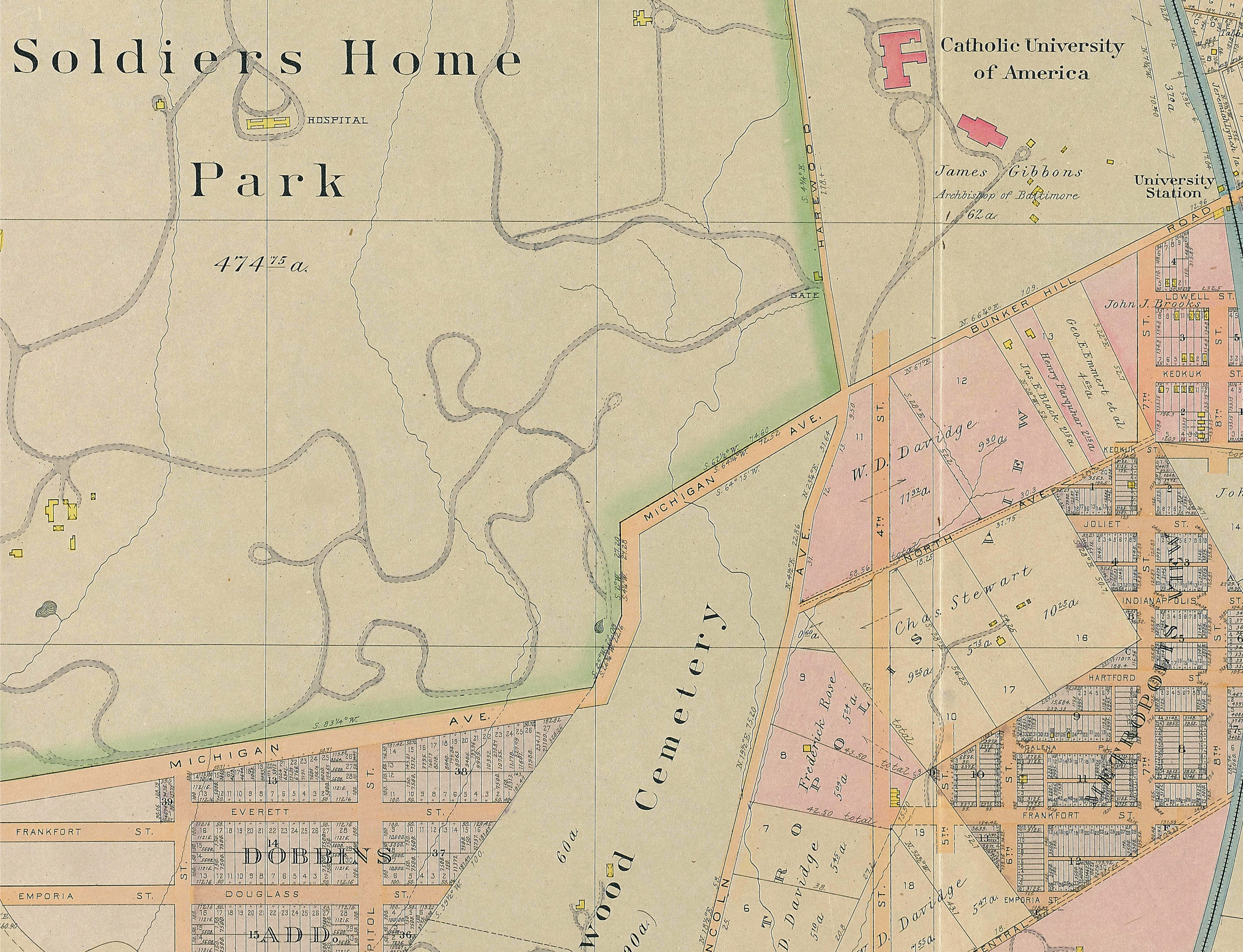
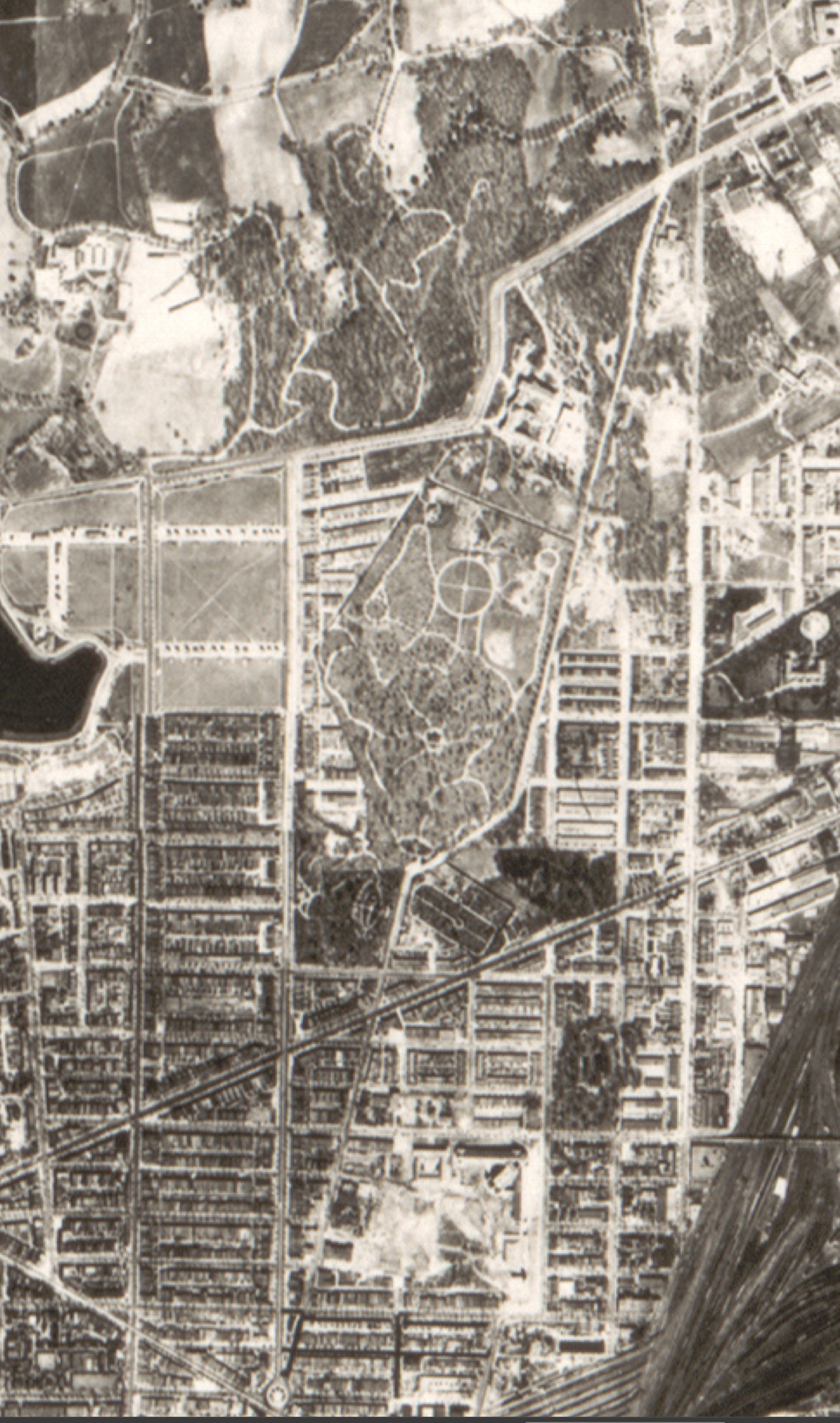
Both the Soldiers’ Home and Glenwood Cemetery were popular spots for carriage rides and picnics in the late 19th century, and Lincoln Avenue was well utilized. It remained a primary route until 1888, when 4th Street was extended north from Eckington to Bunker Hill Road. A year later, an electric streetcar ran up 4th to Catholic University. See the map below.
As Washington County developed piecemeal, new streets became a huge issue. Without regulations, developers of new subdivisions platted their acreage to best adapt to the configuration of the land and provide them with the highest number of salable lots. But that meant the streets were often not aligned with L’Enfant’s precise north/south grid or even with neighboring subdivisions. Planners began to refer to the new developments as “misfit subdivisions.”

In 1886, District Commissioners tried to take control by insisting that all future subdivisions conform to the “general plan” of Washington’s streets. Brookland, platted in the following year, did conform to the grid, even though the commissioner’s edict did not have the force of law. That didn’t happen until 1888, when Congress passed an act that stated in part: “no future subdivision of land in the District of Columbia, without the limits of the cities of Washington and Georgetown shall be recorded in the surveyor’s office…unless made in conformity with the general plan of the city of Washington.”
But after a good start, things got messy. Developers found themselves at odds with the District commissioners, who were the sole arbiters of whether proposed street layouts conformed to the criteria. Maps were prepared showing not only new roads, but “corrected” roads in some of those misfit subdivisions. Of course, Congress balked at paying for new roads in Washington County, and landowners were uncomfortable with the process of condemning their land for the roads. It all culminated on March 2, 1893, when Congress passed “An act to provide a permanent system of highways in that part of the District of Columbia lying outside of cities.” The Permanent Highway Act attempted a middle ground that would generally conform to the grid, while making allowances for terrain and existing subdivisions.
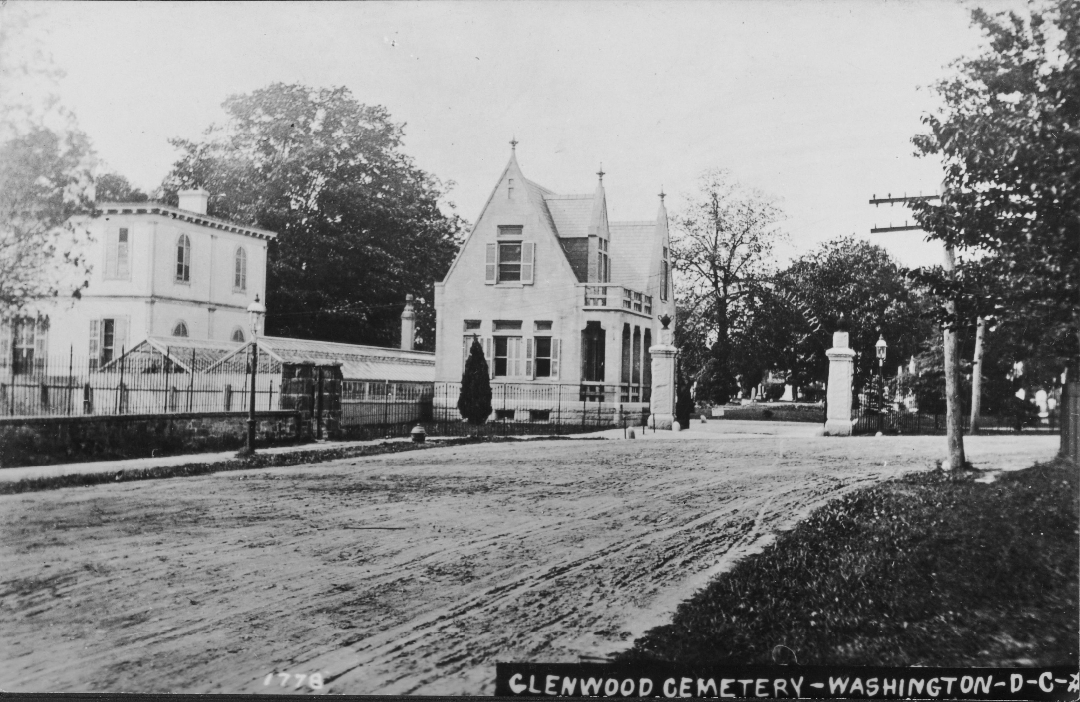
The 1893 act had planners publishing all sorts of maps with proposed roads, including some that would cut through Glenwood Cemetery. The Glenwood board fought back, accusing the District commissioner of wanting “…to divert Lincoln Avenue through a portion of the grounds.” One map showed a proposed road laid out “so as to cut off the present entrance, gateway, and extensive greenhouses.” But the cemetery stood on their original charter with the city, which prohibited the encroachment of city streets onto Glenwood property. It was an extended struggle that went on for six years until an agreement was reached in 1899. In exchange for Glenwood giving up a strip of land on the northern border to extend Michigan Avenue, the city agreed to a “perpetual injunction” against running streets through the cemetery.
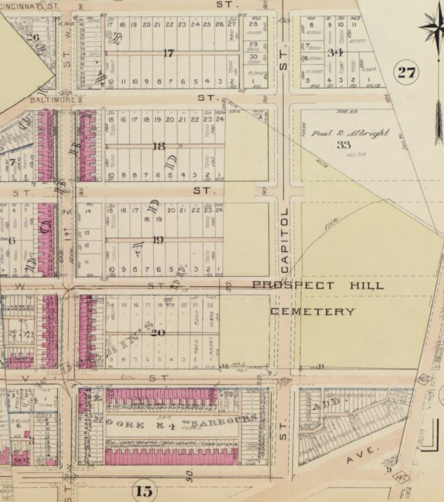
Prospect Hill Cemetery, also on Lincoln Avenue, was not as lucky. Adjacent to Glenwood on the south, Prospect Hill was a German-American cemetery, founded in 1858. The city very much wanted to extend North Capitol Street all the way to the Soldiers’ Home and Michigan Avenue, but the grounds of Prospect Hill were in the way. The fight to condemn the land and run North Capitol Street through would go on for twelve years, until the city and the cemetery finally came to terms in 1897 and the street was allowed to be completed, substantially reducing the size of the cemetery.
That same year, Glenwood Cemetery ran into some significant financial difficulties and decided to sell the northern section of their land to Maurice Talty, representing the Sisters of Notre Dame de Namur, who were looking for land to start Trinity College. It was the ideal location for the new Catholic women’s school, just a few hundred yards west of Catholic University, which had opened in 1889 and did not admit women.

Look closely at the map above and you can see the farm of Frederick Rose, on the east side of Lincoln Avenue, opposite Trinity. For many years, Rose operated a wine house there with grapes grown on his property, and perhaps occasionally served other beverages . More than once he fell afoul of the law, as in this case from 1883:

That small shanty clearly grew over the years. According to Trinity College history, Rose called his place the Red Rose Inn, and he did good business there for a time. But his tavern fronted on Lincoln Avenue, and when 4th Street was extended with the streetcar, it drew traffic away. A new law that severely restricted wine houses within one mile of the Soldiers’ Home also caused him difficulties and more arrests. He tried his hand at other businesses with little luck, became depressed, and in 1903 took his own life.

Rose’s wife Katherine carried on for a short while, but soon decided to sell the property. That worked out well for Trinity College, who were looking to expand. In 1913 they bought the Rose estate, including the tavern building. Now their campus extended all the way to 4th Street, but Lincoln Avenue ran right through the middle of it.

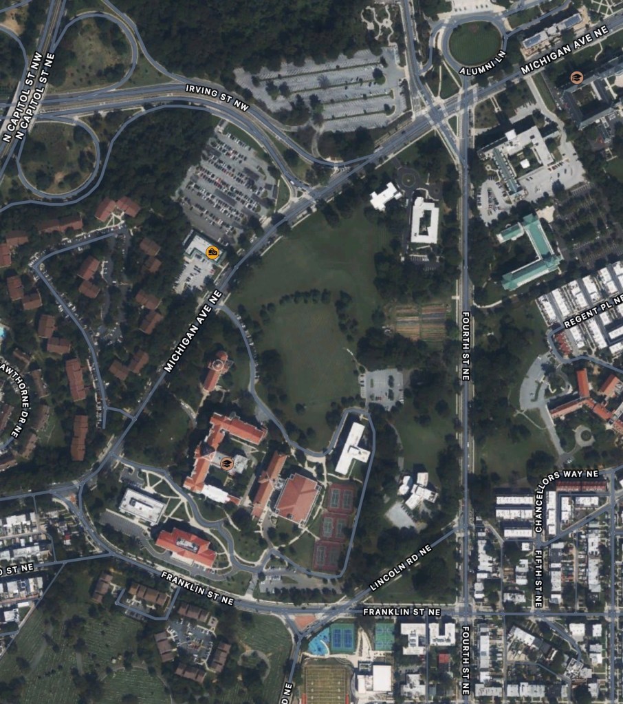
In the 1930s, Trinity began petitioning the city to re-route Lincoln Road. It took some time, but eventually the college and the city worked out a deal. If the city could take a strip of Trinity’s land to run Franklin Street through to Michigan Avenue, they would divert Lincoln Road to 4th Street, so it would no longer cut through campus. It was approved and construction completed on August 29, 1938. In addition, now that Lincoln Road would no longer meet Michigan Avenue, the intersection with 4th Street there was reworked to better meet with Harewood Road, giving us the configuration we have today.
Another note about DC’s roads. After the 1893 Highway Act, attention was turned to the naming of all these streets. That is a topic for another post, but one of the outcomes was a decision that only states could have avenues named for them, the rest would be called streets, except for the older thoroughfares, which would be called roads. Thus, Lincoln Avenue was changed to Lincoln Road, the designation by which we know it today.
Here are a few more photos of Lincoln Road you might find interesting. Click to enlarge:


Sources:
Carroll, James, CUA Scrapbook, ACUA Photographic and Audiovisual Collections. 1920
Eig, Emily Hotaling, Glenwood Cemetery, National Register of Historic Places Nomination, 2016
Harrison, Michael R., The “Evil of Misfit Subdivisions”: Creating the Permanent System of Highways of the District of Columbia. Historical Society of Washington, D.C., Washington History Spring/Summer 2002
Keenan, Sister Angela Elizabeth, Three Against the Wind. Westminster, Maryland, Christian Classics, Inc. 1973
Mullaly, Sister Columba, Trinity College Washington D.C.: The First Eighty Years 1897-1977. Westminster, Maryland, Christian Classics, Inc. 1987
Pinsker, Matthew, Lincoln’s Sanctuary: Abraham Lincoln and the Soldiers’ Home. New York, Oxford University Press, 2005
Trinity Washington University, A Report to the D.C. Zoning Commission Pursuant to Order No. 06-42, Dated July 20,2007, Condition 10, Regarding Buildings Aged 50 Years and Older at Trinity. 2008

Many thanks! I’d heard of Truxton Circle, but never knew its story.
LikeLiked by 1 person
My grandparents were married in 1930, and on the back of a church photograph it says (as best I can read my grandmother’s handwriting) “Lincoln Road Methodist Church.”
I’m wondering if anyone would be interested in the photo.
Please reply to my message.
Thank you!
LikeLike
Thank you for the offer, but I don’t think so. It’s a little far afield for me. Thanks nonetheless.
LikeLike