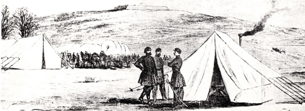
I have always found it frustrating that there seemed to be no photographs of Fort Bunker Hill during the war. Civil War era photographers took their cameras to nearby Forts Lincoln and Totten and even tiny Fort Slemmer, but they all seemed to miss Fort Bunker Hill. The only image I ever found was a sketch in the 1961 pamphlet “Guide to Defenses of Washington” by Stanley McClure:
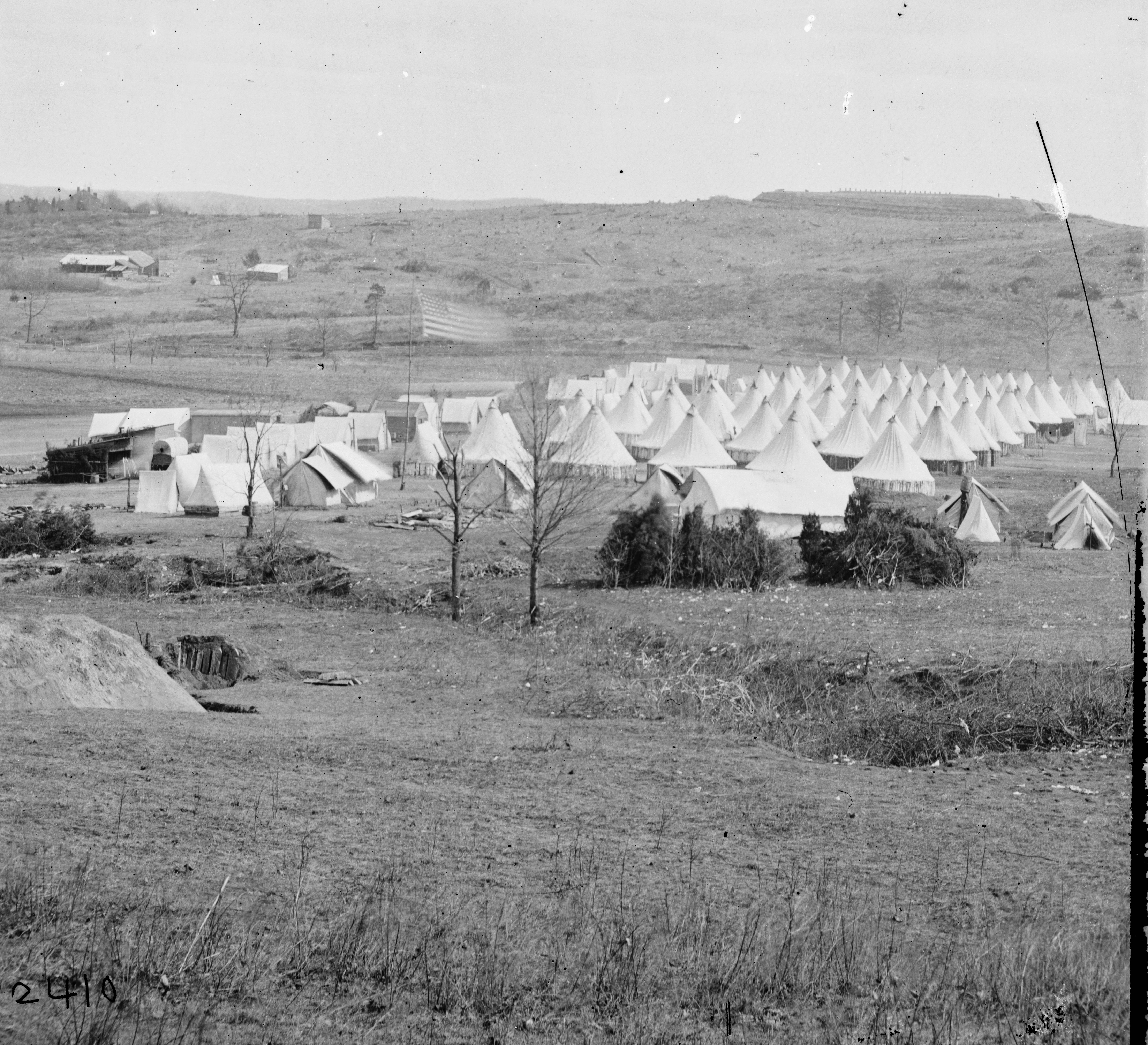
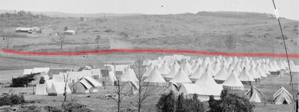
Lately I’ve been researching Nicholas Louis Queen, the wealthy local landowner and farmer whose daughter Ann married Jehiel Brooks, for whom Brookland was named. The Queen farm was sizable and prosperous, with the main house located at present-day 8th and Taylor Streets NE in the Turkey Thicket apartment complex. I wanted to look for a photograph of that house, which seems to have survived into the 20th century, so I went to the Library of Congress Prints & Photographs website. I searched on all the variations of Nicholas Queen’s name with no luck, then tried “Queen estate.” Still nothing. Then I searched for “Queen farm” and brought up a number of hits. One was titled Washington, District of Columbia. Camp of 31st Penn. Inf. (later, 82d Penn. Inf.) at Queen’s farm, vicinity of Fort Slocum. The photo was dated 1861 and bears a striking resemblance to the sketch of Fort Bunker Hill, though I assumed the fort in the background was Fort Slocum, as the caption indicated.
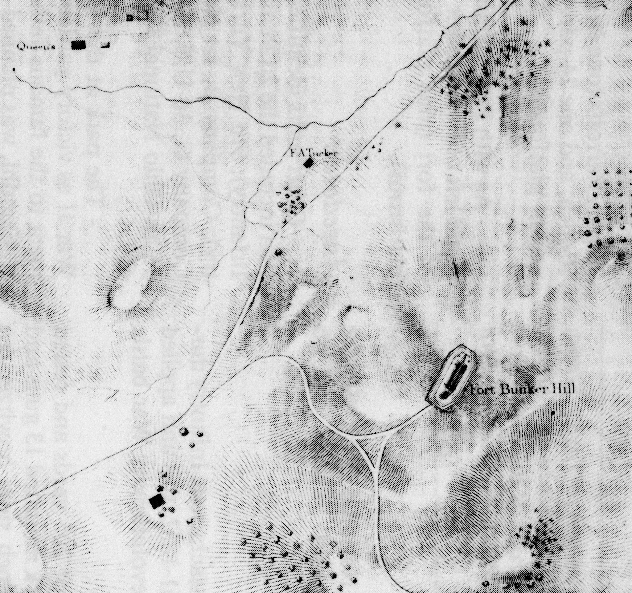
Nevertheless, since I’d been researching the Queen family I thought I would check to see which Queen owned that land near Fort Slocum. I went to the Boschke map from 1861 that gives landowner names. To my surprise, I could find no Queen farms near Fort Slocum. The National Park Service guide to the defenses of Washington lists the landowners name for each fort, and in the case of Fort Slocum shows John F. Callan, L.E. Chittenden, and Mary Walker. No Queens.
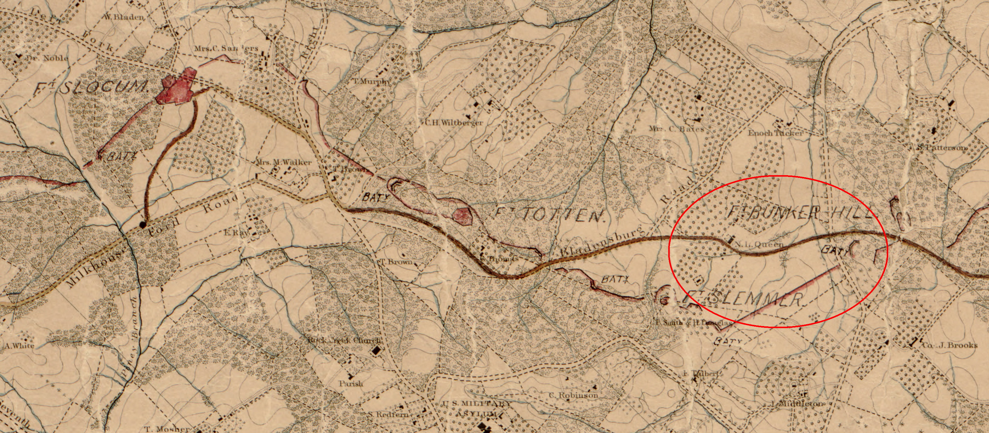
In fact, the nearest Queen was Nicholas Queen, whose farm is circled in the map above. Could it be that the original photographer misidentified the location? I began to search for newspaper stories on the 31st Pennsylvania Infantry and Queen’s farm that might refer to the location. There were a few articles, including this one from the Evening Star:

There were two important clues in that story: the soldiers had named their spot on the Queen farm “Camp Graham,” and it was near the Soldiers’ Home. Another story referred to Queen’s farm as “on the Bladensburg Road,” meaning the colonial-era Georgetown/Bladensburg Road. Fort Slocum is not on that road, though Nicholas Queen’s farm is, and Slocum is also considerably further from the Soldiers’ Home than the Queen property. I was becoming more certain that the photo misidentified the location.
I compared diagrams of the two forts. Fort Slocum was larger and had an angled frontage:

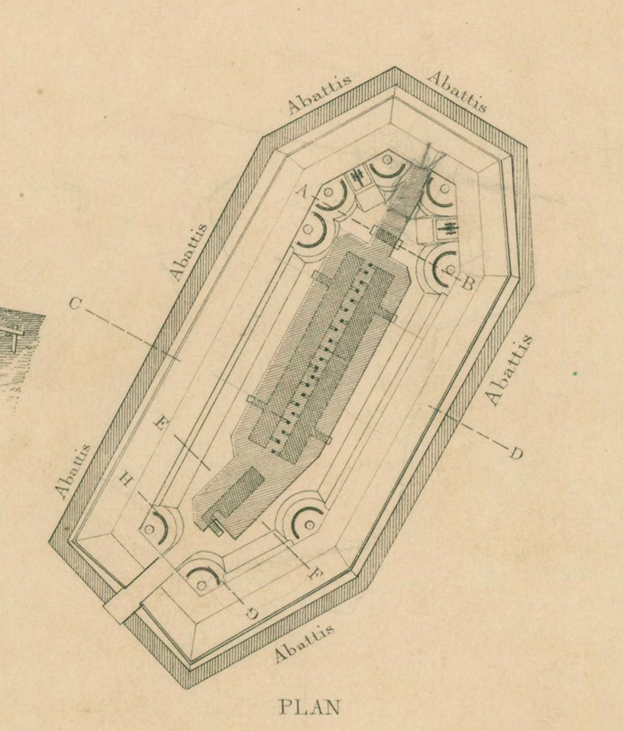
Fort Bunker Hill, on the other hand, had much flatter sides:
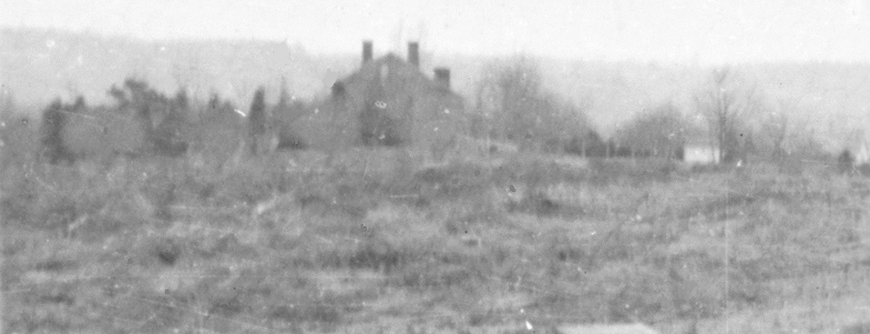
By zooming in on the photo I was able to get a pretty good look at the fort:
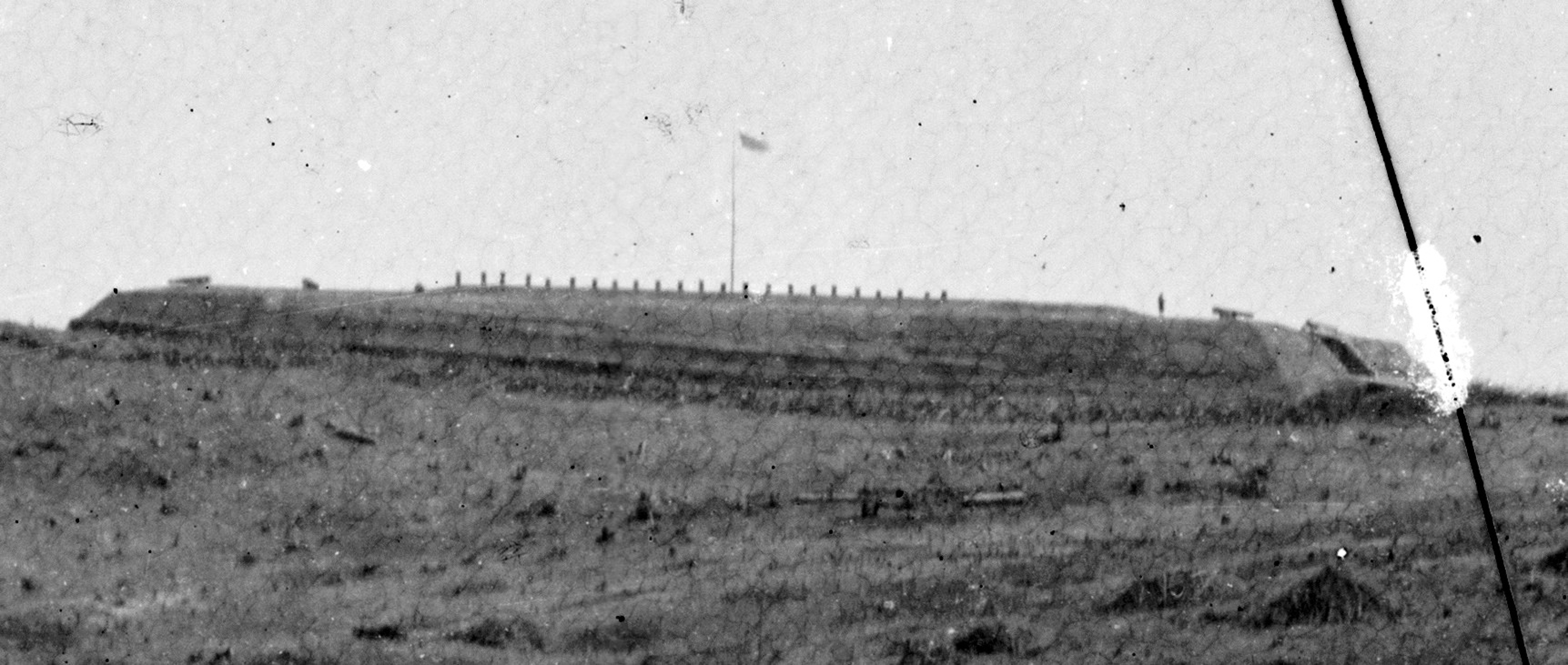
To my eye, it appears to match the plan of Fort Bunker Hill — flat front, cannon mounted on either side of the sally port entrance on the right; and more mounted on the other end, matching the cannon platforms seen in the diagram. A lone soldier stands guard on the parapet. That line of pipes sticking up from the center had me at a loss, though. I thought perhaps they were ventilation shafts for the magazine in the center of the fort, which seems to be indicated in another illustration:

At this point, I decided to contact Steve Phan, National Park Ranger and Historian for the Civil War Defenses of Washington. He was intrigued, and said it’s not at all unusual for Civil War-era photos to be mislabelled or misidentified. He thought I might be on to something, and forwarded my note to Dr. Benjamin Franklin Cooling, an expert on the defenses of Washington and author of two books on the forts. After a quick look, he too thought it might be Fort Bunker Hill and confirmed that the pipes sticking up could be ventilation shafts.
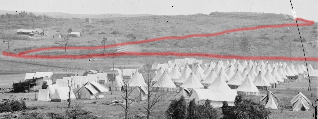
If my supposition is correct and the photo actually shows Fort Bunker Hill, then we are looking at the earliest photo I’ve ever seen of the land that would become Brookland. Colonel Brooks’s mansion, Bellair, would be visible if the camera were turned slightly to the right. The B&O Railroad’s Metropolitan Branch wasn’t built until 1873, so it isn’t in the picture. In fact, I think the camera position was about where the tracks are now, pointing east over the present-day Turkey Thicket baseball field. If that’s correct, Bunker Hill Road should be running across the photo. I believe it is:
In addition, period maps show a curving road leading up to the fort’s sally port:
I believe that curving road is also visible in the photo of the Queen’s farm campsite:
Fort Bunker Hill was brand new when this photograph was made in late fall or early winter of 1861, as the fort was built in August-September of that year. It is evident that the hill has been denuded of almost all trees. That timber was used not only for the interior of the fort, but also for the walls of the conical Sibley tents that comprise the bulk of the campground. Each of those tents could hold 16 soldiers.
In the distance on the upper left, a large farmhouse is visible in a copse of trees. I believe that is the home of George McCeney, who had a sizable farm there. It is now the location of the Franciscan Monastery:
As I continued researching, I discovered that the 31st Pennsylvania was not the only unit camped at Queen’s farm. By searching the term “Camp Graham,” I found that four different units pitched their tents there during this period. Here’s an excerpt from the regimental history of the 23rd Pennsylvania (Birney’s Zouaves) describing their arrival:
Washington and its suburbs was one grand encampment. Troops from every loyal State were being marshalled and prepared for active service… As regiment after regiment arrived, they were organized into brigades and divisions without much reference to the States from which they came, and were encamped contiguous to each other. At Queen’s farm, on the Bladensburg road, just on the outskirts of the city, the Twenty-third Pennsylvania, Colonel Birney; the Thirty-first Pennsylvania, which afterwards became the Eighty-second Pennsylvania, Colonel Williams; the Sixty-fifth New York, Colonel Cochrane; and the Sixty-seventh New York, Colonel Adams, were encamped and formed what was known as Graham’s Brigade, under the command of Brigadier-General Pike Graham, an officer formerly of the United States Cavalry service. This Brigade formed a part of the Division commanded by General Don Carlos Buell.
So, it is clear they named the camp after their brigade commander, Brigadier General Pike Graham. All these regiments would go on to make memorable names for themselves in the war. These were not the soldiers who built and manned Fort Bunker Hill, however, that was the 11th Massachusetts (they also chose the fort’s name), who were encamped on the far side of the fort. Camp Graham served as a kind of way station for troops moving to and from the front lines.
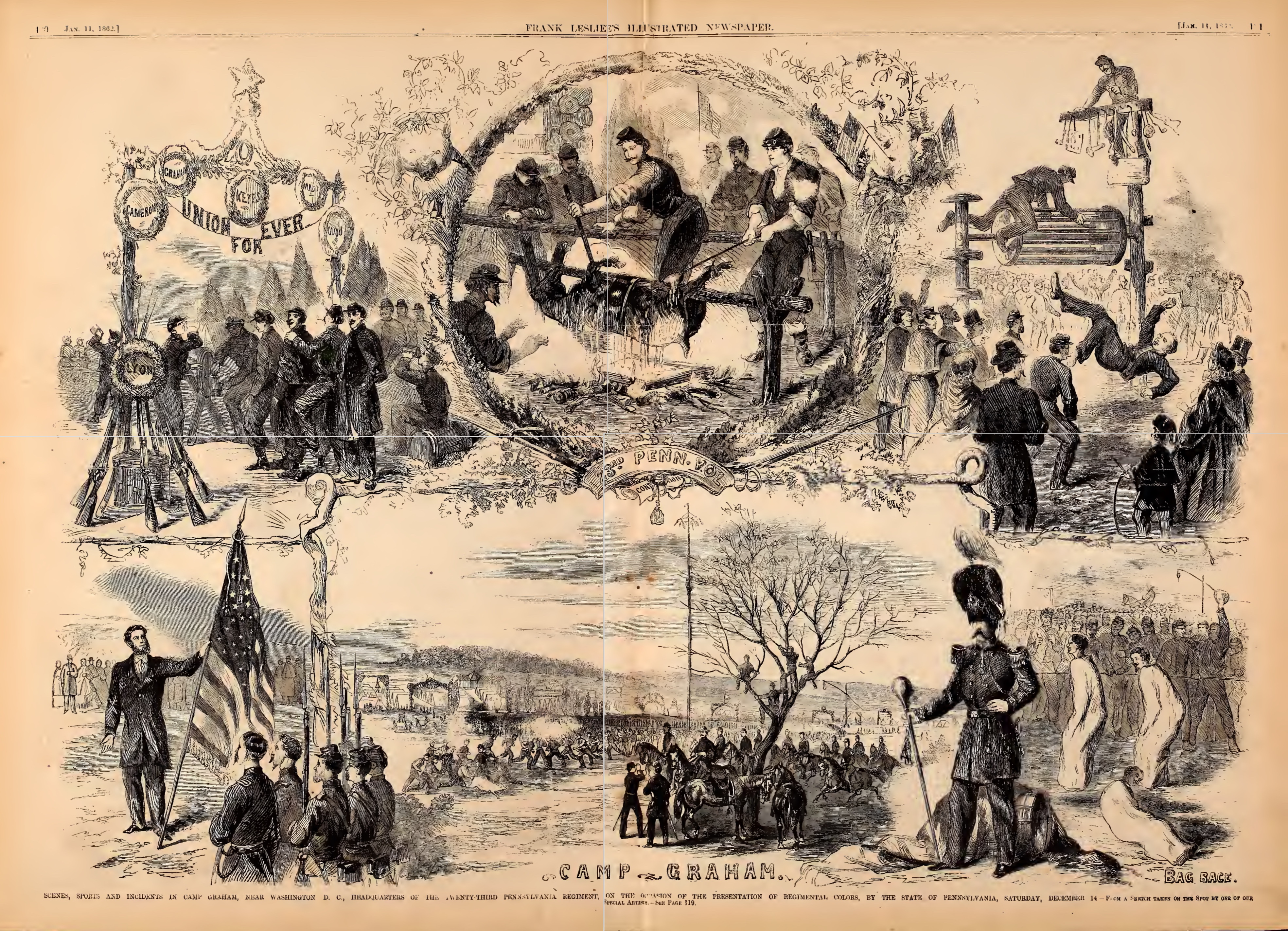
What was life like in the camp? For the soldiers it was mostly drills and discipline, learning the formations and maneuvers for the upcoming battles. They helped maintain the camp and the adjacent forts and roads leading to them. Occasionally though, they could have fun. On November 21, 1861, the 23rd Pennsylvania was presented with the regimental colors in a big ceremony at the camp. This is the description from the regimental history:
The occasion was made one of festivity and ceremony, camp being elaborately decorated with evergreen; each company having an elegant dinner provided. During the day prizes were contended for in pole climbing, sackracing, pigchasing, boxing and other games of amusement, the entire day being given up to pleasure and entertainment, the camp being crowded with visitors from Washington and members of the brigade, the Twenty-third entertaining all who called.
One of those visitors was an artist from Frank Leslie’s Illustrated Newspaper, who created a large drawing of the event:
Some soldiers were also able to bring their families with them, and that was the case at Queen’s farm. The wives of soldiers often worked as laundresses and cooks at the camps. I found a total of six images taken by the photographer that day in 1861, including this one, titled Washington, District of Columbia. Tent life of the 31st Penn. Inf. (later, 82d Penn. Inf.) at Queen’s farm, vicinity of Fort Slocum:
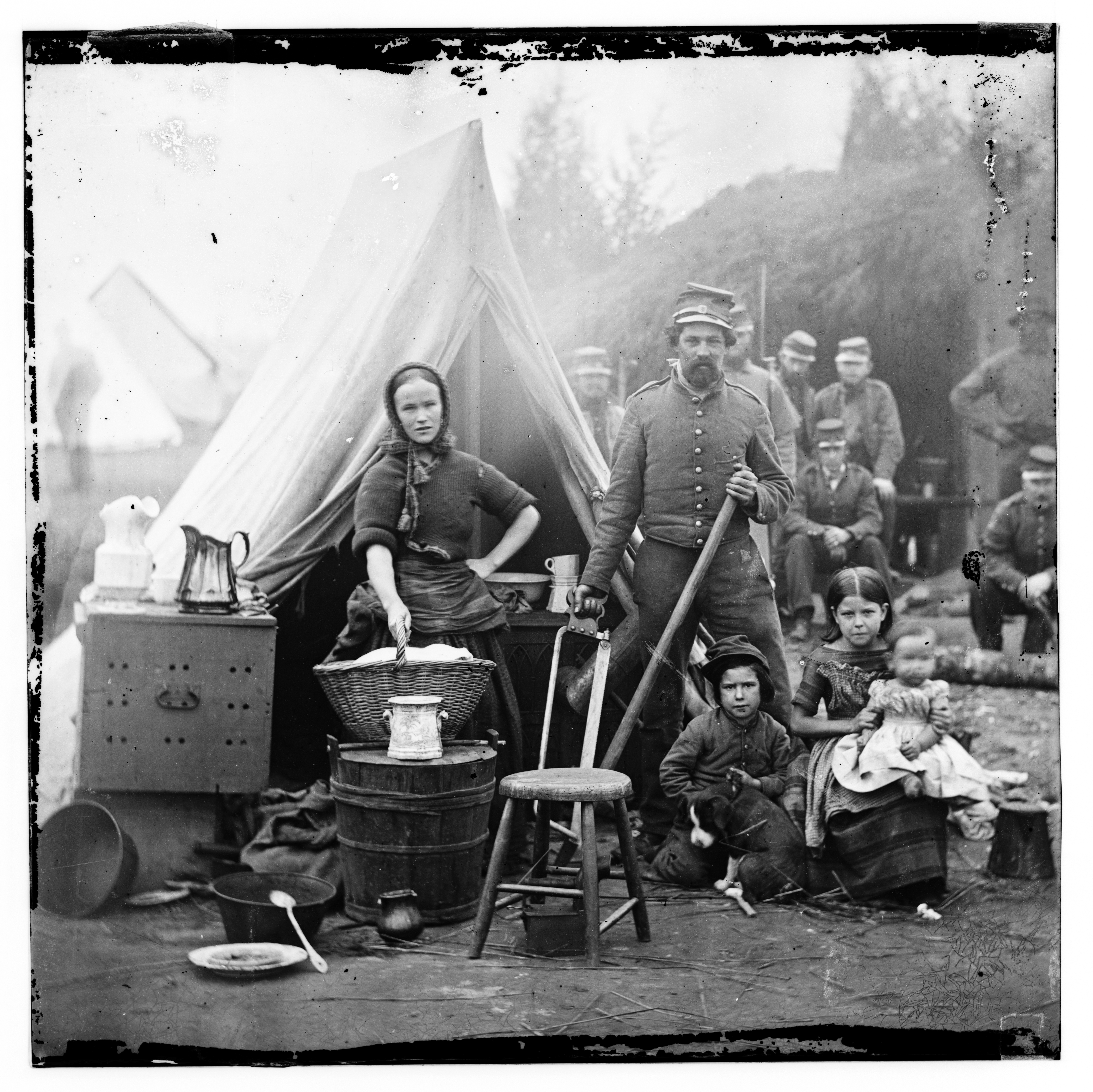
A while back, Time colorized this famous photo, and I think it serves to humanize the family even more.

I walked by Turkey Thicket field last week, stopped for a moment, and tried to envision this family and all the soldiers living on that spot 157 years ago. It wasn’t difficult. It would be a perfect place to camp, especially before they undergrounded the streams that ran through there. And I wondered what the Queen family and Jehiel Brooks thought about all those people living on their land. We know that Brooks challenged the Army’s takeover of his property, but to no avail. Nicholas Queen died in 1860, so he never saw the camp or the fort. His son Henry was in charge of the farm when the war began.
I will continue to research the photo and try to get absolute confirmation that it is Fort Bunker Hill. I would welcome any additional information, including any that might disprove my contention. But I am now convinced the picture shows us Fort Bunker Hill during the early days of the Civil War.
**Update 5/23/2018: A day after I posted this, I heard from Walton Owen, the co-author of Mr. Lincoln’s Forts. He confirms, based on the visible evidence of the unusual ventilation system, that the photo does indeed show Fort Bunker Hill.
————–
Sources:
Barnard, John Gross, A Report on the Defenses of Washington, to the Chief of Engineers, U S. Army Corps of Engineers, Corps of Engineers Professional Paper No. 20. Washington, DC: The Government Printing Office, 1871.
Barnard, John Gross and William F. Barry, Report of the Engineer and Artillery Operations of the Army of the Potomac from Its Organization to the Close of the Peninsular Campaign, New York: D. Van Nostrand, 1863.
Cooling, Benjamin Franklin and Owen, Walton H., Mr. Lincoln’s Forts: A Guide to the Civil War Defenses of Washington, White Mane Publishing Company, Shippensburg, PA. 1988
Cooling, Benjamin Franklin, Symbol, Sword, and Shield; Defending Washington During the Civil War, White Mane Publishing Company, Shippensburg, PA 1991
Henley, Laura Arlene, “The Past Before Us: An Examination of the Pre-1880 Cultural and Natural Landscape of Washington County.” PhD dissertation, Catholic University of America, 1993
History of the Twenty Third Pennsylvania Infantry, Birney’s Zouaves, Three Months and Three Years Service, Civil War 1861 — 1865. Compiled by the Secretary, Survivors Association Twenty Third Regiment Pennsylvania Volunteers, 1903-4
United States Department of the Interior National Park Service, The Civil War Defenses of Washington, Washington DC, 2004
Williams, Kim Prothro, Lost Farms and Estates of Washington, D.C., The History Press, Charleston, SC, 2018

Top notch research! Way to pin down the only extant photo of Ft. Bunker Hill, adding something very tangible to the historical record.
Excellent other photos of similar forts, soldiers and their wives, etc.
What interesting history right in our city. Cheers on all your great work, Robert!
LikeLike
Thanks, Walter! I live on the slopes of Bunker Hill and had always been interested in the history of the fort.
LikeLiked by 1 person
this is super helpful I am doing a proguckt on this
LikeLike