In July of 1861, the loss at the first battle of Bull Run and the rout of Federal troops scared Washington badly and spurred the Army to quickly construct protective fortifications. By the time the Civil War ended in 1865, there were 68 enclosed earthen forts ringing the city, along with additional batteries, rifle pits, blockhouses, and military roads connecting them all. In four years of war, the Army’s engineers had managed to turn the sleepy national capital into one of the most heavily fortified cities in the world.
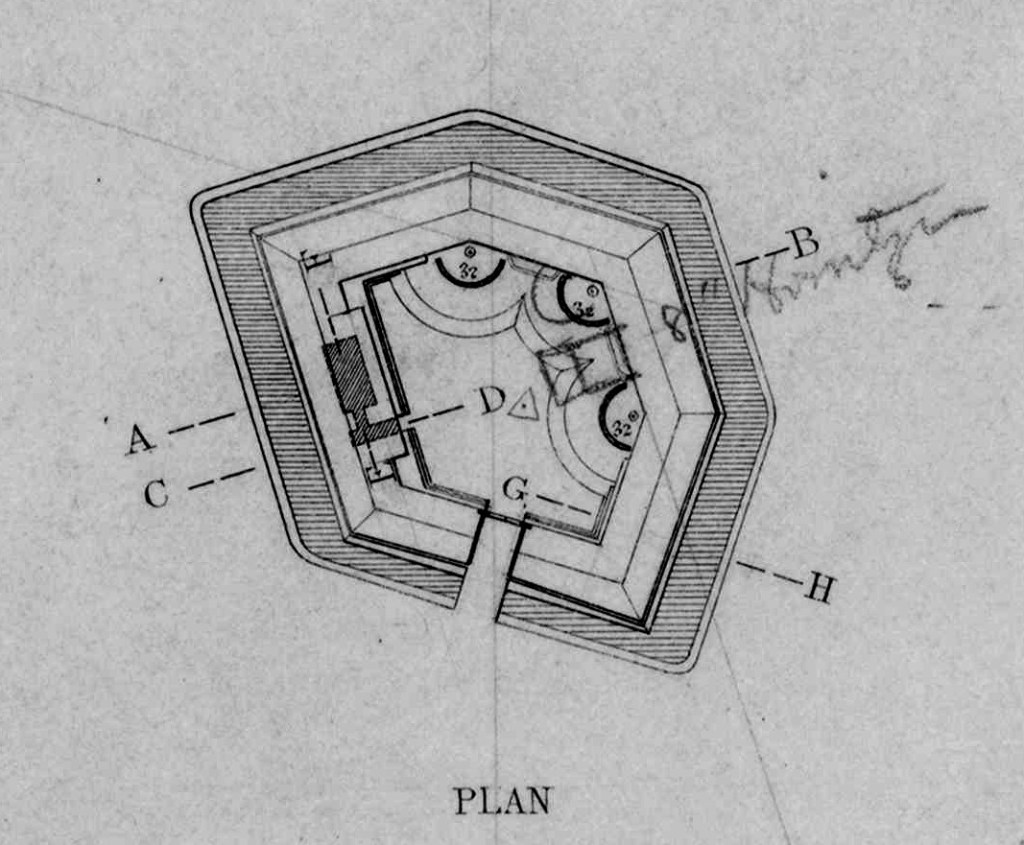
Fort Slemmer was built in November 1861, to fill in the gap between forts Bunker Hill and Totten, on land that is now a part of the Catholic University of America. It was one of the smallest of the enclosed forts, with only three 32-pounder seacoast guns and one 8-inch howitzer.
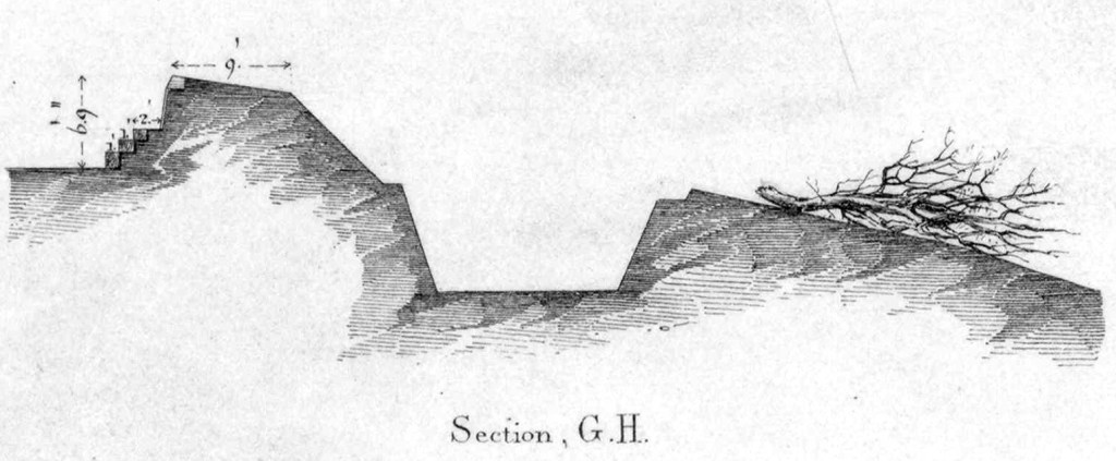
Below is a cross section of the eastern portion, showing the interior of the fort on the far left, the rampart, with a 9 foot parapet, the ditch around the fort, and the sharpened tree branches known as abatis. The slope the abatis sits on is called the glacis, and was angled so cannon fire would hit it and bounce up and over the fort. The guns were mounted en barbette, i.e. they sat on raised platforms and fired over the parapet, not through an opening in the rampart wall, so they were more exposed.
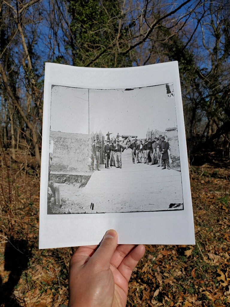
And here is the completed fort, photographed in 1862 or 1863. This is an exceptional image that shows in detail the elements of the fort. The howitzer hasn’t been mounted yet, but the three cannon are apparent. The earthen walls are well defined but would need constant maintenance. Wooden planks suppport the inner wall. The ditch along the outside of the walls is there, with the men marching over it on a wooden bridge. The abatis would be intimidating for any enemy to try to breach.

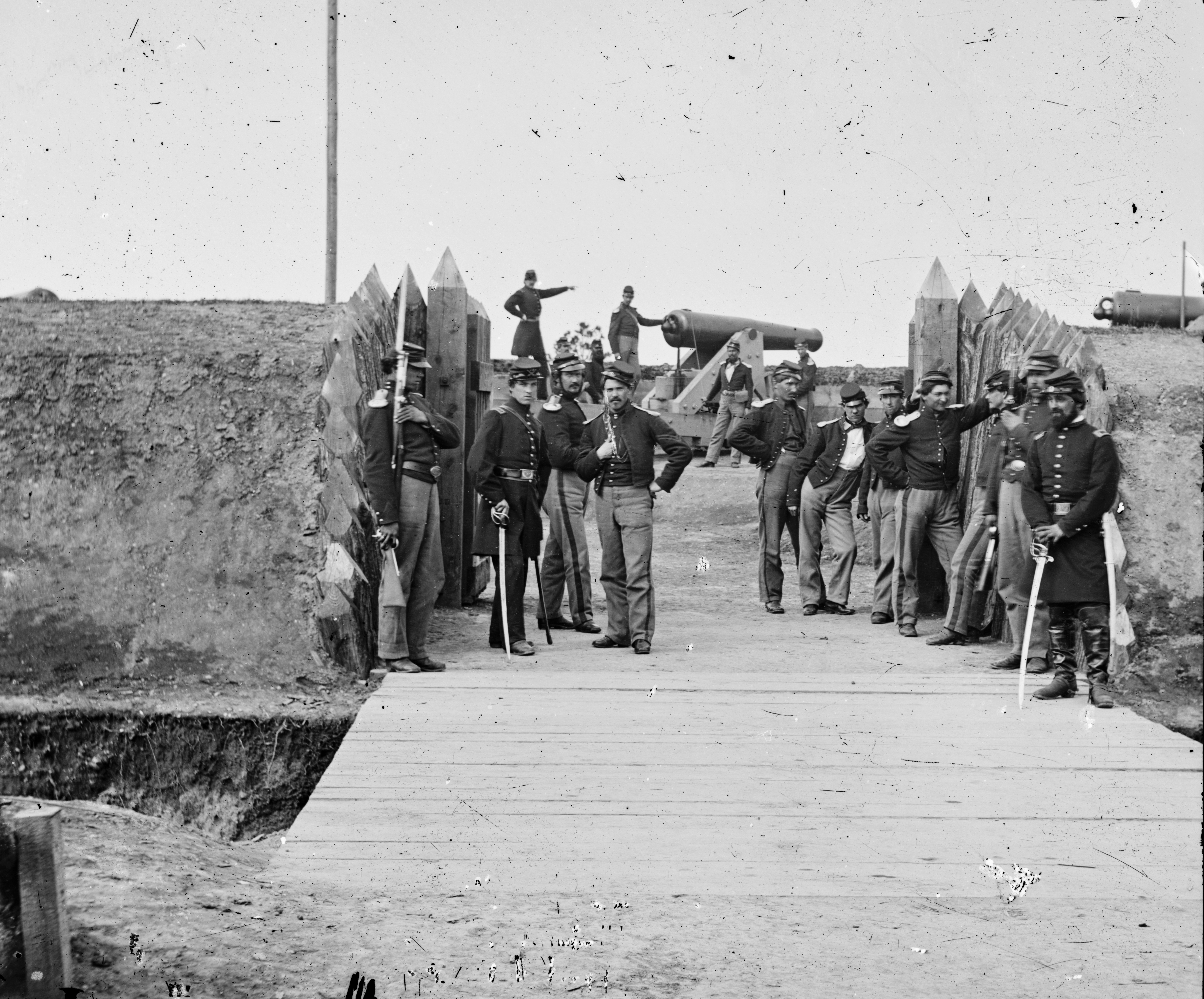
A second photograph shows a group of soldiers lounging at the sallyport, with the ditch and bridge in more detail as well as the raised mounds on which the cannon sit.
When Major John G. Barnard was given the assignment of constructing the defenses of Washington, he and his engineers were under intense pressure to work quickly. Barnard picked the sites for the forts “with little or no reference to the rights of the owners or the occupants of the lands — the stern law of ‘military necessity’ and the magnitude of the public interests involved in the security of the nation’s capital being paramount to every other consideration.” No compensation for damage or occupation was promised when the forts were built; the landowners were left to fend for themselves as best they could. Some abandoned their property for the duration, others, particularly the farmers, stayed and tried to eke out whatever living they could manage.
I’ve written before about how the construction of Fort Bunker Hill affected the local landowners in this area. Fort Slemmer was built on a 24-acre tract that was owned by Henry Douglas, a florist.

Unlike the other nearby landowners, Douglas was not a slaveholder and didn’t even live on the property. He used the land to grow fruit and ornamental trees, grasses and sod, different kinds of timber, and all manner of ornamental shrubs and plants. He sold them at his downtown greenhouse, which was in a prime location — the corner of 15th and G NW, across the street from the Treasury building and a block from the White House.
Henry Douglas could not have been happy as he watched the soldiers cut down his trees and rip up his plants to build the fort, dig rifle pits, and construct a military road. Given that it was a relatively small tract to begin with, there was no way he could continue to use the land during the war. It appears he managed to survive by relying on what he could grow in his downtown greenhouse.
At war’s end in 1865 the Army decided to offer some compensation to the forlorn landowners. They had constructed many timber buildings around each of the forts; barracks, guardhouses, stables, mess halls, etc., and decided to offer those buildings as compensation. Most took the deal, but a number, including Henry Douglas, felt it was not good enough. The Army sent Colonel Marshall Ludington to those landowners to take reports. Here is the report for Fort Slemmer:
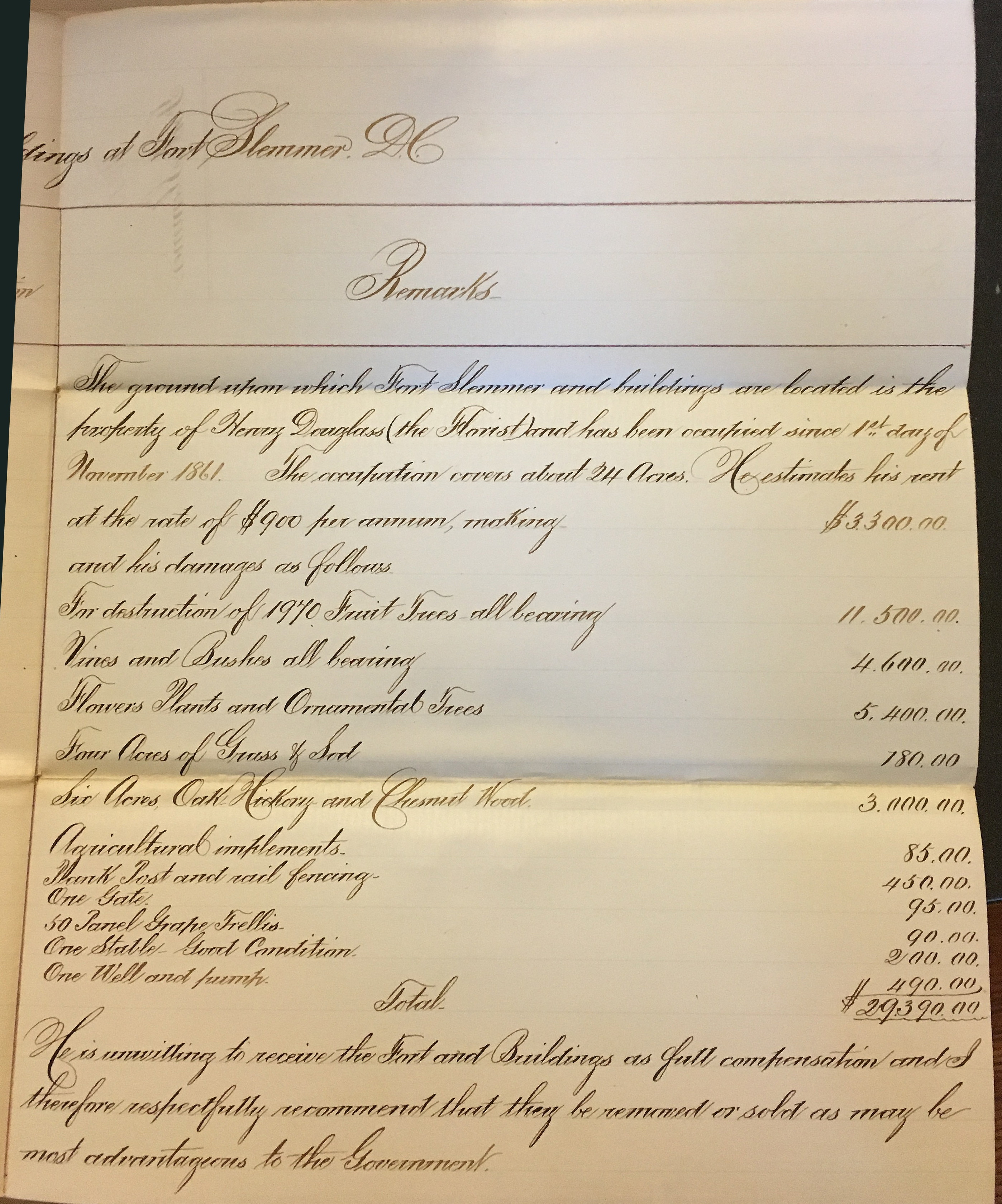
In case you can’t read that gorgeous cursive, it says:
“The ground upon which Fort Slemmer and buildings are located is the property of Henry Douglass (the Florist) and has been occupied since 1st day of November 1861. The occupation covers about 24 acres. He estimates his rent at the rate of $900 per annum, making $3,300 and his damages as follows.
For destruction of 1,970 Fruit Trees all bearing – 11,500
Vines and Bushes all bearing – 4,600
Flowers, Plants and Ornamental Trees – 5,400
Four acres of Grass and Sod – 180
Six Acres Oak, Hickory and Chestnut Wood – 3,000
Agricultural implements – 85
Plank Post and rail fencing – 450
One Gate – 95
50 Panel Grape Trellis – 90
One Stable Good Condition – 200
One Well and pump – 490
Total $29, 390
He is unwilling to receive the Fort and Buildings as full compensation and I therefore respectfully recommend that they be removed or sold as may be most advantageous to the Government.”
Douglas was asking for a huge amount, nearly a million dollars in today’s money, and it was unlikely the government would even consider it. At best they might have offered him a portion of the rent, but although I have gone through the war claims files at the National Archives, I have yet to uncover any documentation of his claim. Like many others, Douglas likely had to absorb the loss and move on.
But the land was returned to him, and it appears he went back to growing some plants and vines, if not his full orchards. It is likely that he and his co-workers stripped the logs and timber from the fort and shoveled the ramparts into the exterior ditch, leveling the ground as much as possible. Around 1874 Douglas sold the tract to William Hatcher, one of his assistants, who continued to grow and sell sod on the site. Hatcher sold the property to the Marists in 1899, and they built a college there, just south of the fort site. Catholic University acquired the land and building in the 1950s. A campus road was cut through that chewed a bit off the rear of the fort, including the area of the sally port.
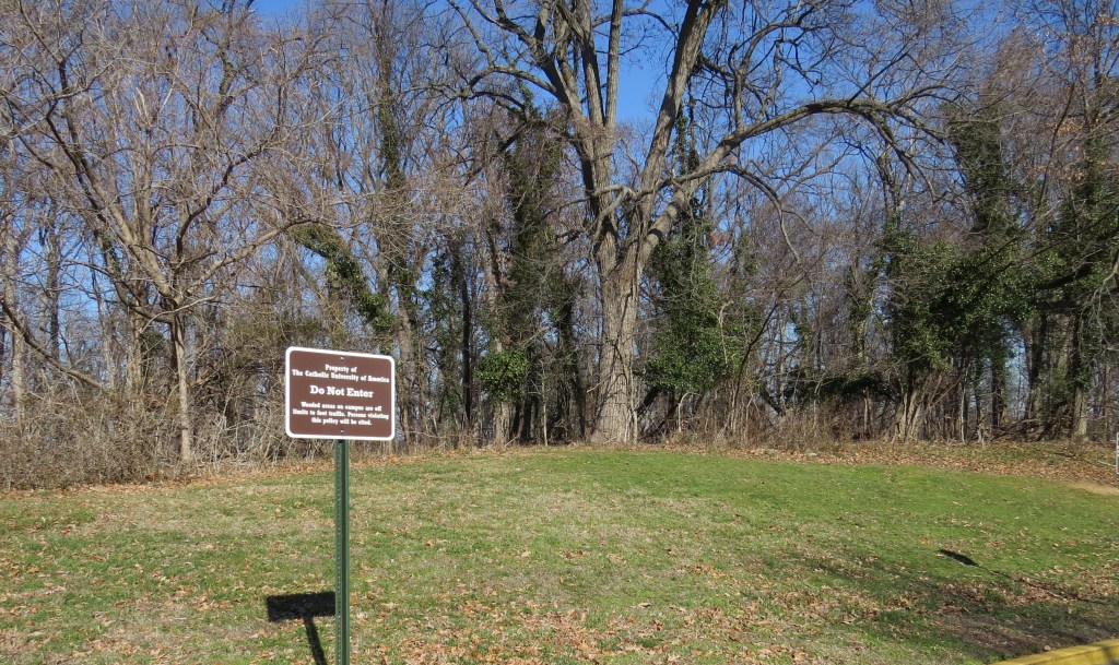
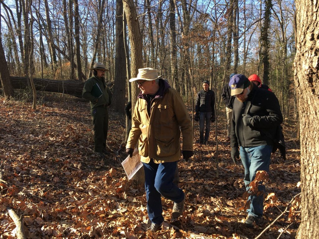
Recently, working with Maria Mazzenga, curator of the American Catholic History Research Center at CUA, we assembled a team to explore the remains of the site, which is normally closed to the public. Along with National Park Service Ranger Steve Phan, NPS historian David Lowe, Civil War historian Noah Andre Trudeau, and CUA history professor Stephen West, we traipsed around the the slopes to see what remnants might still be visible.
Phan and Lowe have been revitalizing interest in the Civil War Defenses of Washington in the last few years, conducting tours, writing articles, and creating detailed maps of the various fort sites under Park Service control. David Lowe uses LiDAR mapping to get an accurate picture of the terrain. Here is the LiDAR map of the Fort Slemmer site he overlaid with the outline of the fort:
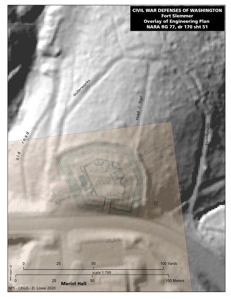
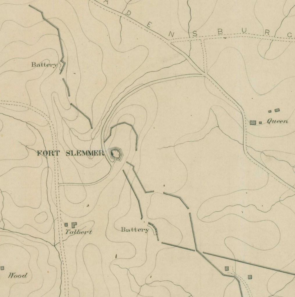
The outerworks marked on the map were part of a system of rifle trenches around and connecting the forts. Here is a portion of an engineering map showing the works around Fort Slemmer:
In addition to the outerworks, we could see that the military road that ran between the fort and a small stream left some traces, including a brick-lined drainage ditch that ran down the middle of the road and could possibly date from the Civil War. As for what’s left of the fort itself, here is David Lowe’s analysis:
“In several locations, structure is visible. The western ditch seems visible for 100 feet or so. Several points of the western face may be traceable and used for a more accurate plan overlay. Along the eastern perimeter, along the existing social trail, one can see the glacis as it breaks from the original ground contour. One or more of the gun platforms may be intact, disguised by vegetation. An improved fort plan overlay, based on several newly observed points of correspondence, may help clarify some of the interior works. The shallow remains of the ditch of the fort can be followed around its front.”
In the end, we found more evidence of the fort and its outerworks than we were expecting. It is not just a featureless hill, as it has been described in the past. But it is also not preserved on the level of Fort Totten or Fort DeRussy, which are quite well-defined. Nonetheless, it remains a notable part of the Civil War defenses of Washington, and thanks to all who participated in our little trek.
Sources:
Barnard, John Gross, A Report on the Defenses of Washington, to the Chief of Engineers, U S. Army Corps of Engineers, Corps of Engineers Professional Paper No. 20. Washington, DC: The Government Printing Office, 1871.
Barnard, John Gross and William F. Barry, Report of the Engineer and Artillery Operations of the Army of the Potomac from Its Organization to the Close of the Peninsular Campaign, New York: D. Van Nostrand, 1863.
Civil War Defenses of Washington Historic Resource Study, National Park Service, 2004
Cooling, Benjamin Franklin and Owen, Walton H., Mr. Lincoln’s Forts: A Guide to the Civil War Defenses of Washington, White Mane Publishing Company, Shippensburg, PA. 1988
Cooling, Benjamin Franklin, Symbol, Sword, and Shield; Defending Washington During the Civil War, White Mane Publishing Company, Shippensburg, PA 1991
Henley, Laura Arlene, “The Past Before Us: An Examination of the Pre-1880 Cultural and Natural Landscape of Washington County.” PhD dissertation, Catholic University of America, 1993
National Archives and Records Administration, RG92, Records of the office of the Quartermaster General, Entry 225, Consolidated Correspondence File, Defenses of Washington, DC, Box 484.
National Archives and Records Administration, RG77, Records of the office of the Chief of Engineers

There were overgrown earthworks down along McCormick Road. When Catholic University built the new dorm , the earthworks were bulldozed. There is one small piece of them left. I grew up and still live a few blocks away.
I’d be happy to show you what I’m talking about
LikeLike