Exploring a fascinating 1863 photograph.

This is not a post about Brookland, although it deals with a spot nearby. I was researching one of the Lincoln assassination conspirators who hid out in the future Brookland area, when I came across this photo from 1863. It shows the 17th New York Battery posing in a field in front of their artillery depot, Camp Barry. The camp is on the rise where you can see the tents and long sheds. This photo caught my attention not only because of its unusual clarity but because the background shows some interesting details I’ve never seen before.
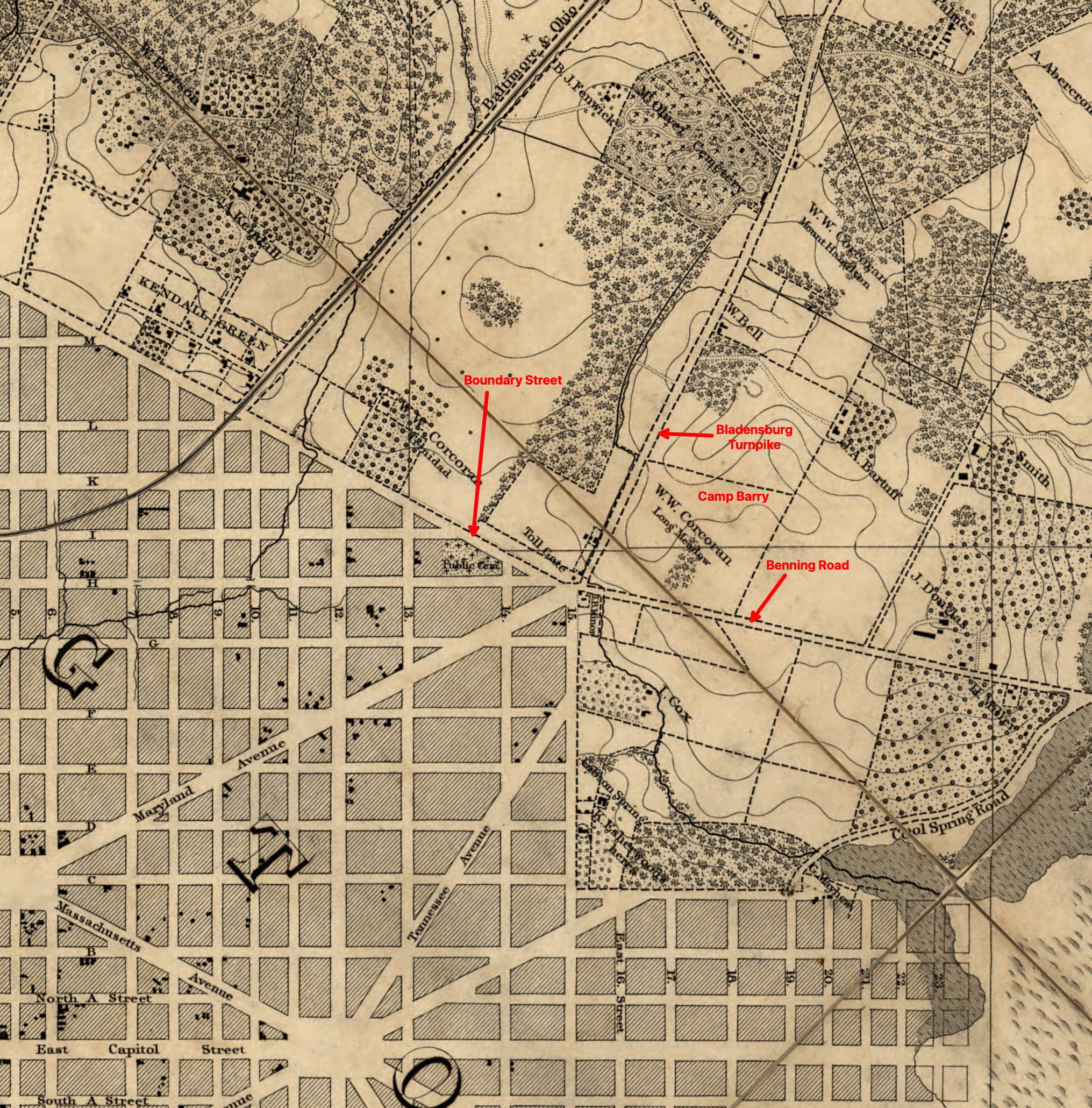
Camp Barry was located on a tract of land owned by W.W. Corcoran and called Long Meadow. It lay at the intersection of six streets – Boundary Street (Florida Avenue), H Street NE, Maryland Avenue, 15th Street NE, Benning Road, and the Bladensburg Turnpike, which today we call Bladensburg Road. Here is that intersection in 1861:
Look again at the two big hills in the background of the top photo. The larger one in the center is Mount Hamilton, a property also owned by Corcoran, which is today part of the National Arboretum. Their famed azalea displays now grace the slopes facing the camera.
The hill on the left side of the photo is Mount Olivet Cemetery. Opened in 1858, Mount Olivet, a Catholic cemetery started by the Archdiocese of Baltimore, quickly absorbed many interments from the already overcrowded older Catholic cemeteries. Mount Olivet was only five years old when this photo was taken, but some monuments can be discerned on the slopes, as you can see in this closeup:


The road rolling up and down between the two hills is the rustic Bladensburg Turnpike. Although the definition is a bit lost today, a turnpike was originally a toll road, and Bladensburg Pike fit the definition, with a toll gate at the intersection where there was a small cluster of houses, as you can see on the map. The 7th Street Turnpike, today’s Georgia Avenue, was also a toll road.
I believe the actual toll gate is visible in the photo, with one half swung open. The houses seem to be pretty accurately depicted on the map as well. Here’s a closeup:

As best I can figure it, the troops are gathered just in front of G Street, with the camera facing northwest. Here’s my best guess of the different roads leading to the intersection. Click to enlarge:

W.W. Corcoran was a wealthy banker and philanthropist, who contributed much to the city’s culture. But he was also a southern sympathizer and decided to spend the Civil War years in England, leaving some of his properties unattended. The Federal Army scooped up a number of them, including Long Meadow. After the war Corcoran returned, continued his philanthropy, and sold Long Meadow along with some other parcels. In 1871, Graceland Cemetery was started on the site. A racially integrated cemetery, it primarily served the city’s growing African American population.
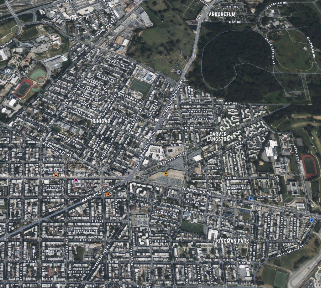
Graceland existed for only 23 years. After numerous complaints about the burials affecting the water supply and the lingering smell, it was shutdown in 1894. In 1936 Maryland Avenue was extended through the property, which was then purchased by the Washington Railway and Electric Company, who wanted to add to their streetcar line. They also erected an electric powerhouse and other maintenance buildings, which eventually morphed into Pepco. In 1978, Pepco sold the land to the Hechinger Company, who built Hechinger Mall on the site. It still stands today. Hechinger was a large regional chain of hardware stores, centered in Landover, Maryland. After many successful decades, Hechinger couldn’t compete with Home Depot and Lowe’s, and closed in 1997, though the name remains on the mall. The site today is part of the Carver Langston neighborhood.
You can see from the photograph and the map just how sparsely populated the eastern part of the District was at that point. There were some houses along Maryland Avenue and H Street, but a lot of open scrub as well. But it wouldn’t take long after the Civil War for the District’s population to explode, and all those empty places would soon be filled in. Here’s what it looks like today:
As for the 17th New York Battery, they served at Camp Barry until mid-1864 when they were sent to join the Army of the James at Petersburg. In 1865 they participated in the fall of Petersburg and Lee’s surrender at Appomattox Court House.

Excellent work, Robert. I had never seen this photo before
LikeLiked by 1 person
Thanks for pulling this together and sharing.
LikeLike